Fixed vs. Transient SST
HICCUP can generate a file with SST and sea ice data that matches the format that E3SM expects when running a hindcast with prescribed ocean/ice conditions. Several options are implemented to control how the time coordinate of this data is handled in the sstice_slice_and_remap() routine.
A typical workflow would be to use a pair of files from NOAA with daily-mean data for a given year. The default behavior in HICCUP is produce a single SST/ice file with a single time slice that matches the date used for the atmospheric initial condition (time_slice_method="match_atmos"). A similar option will just use the first time available in the SST data (time_slice_method="initial"), which is meant to accommodate SST/ice data that has already been modified to contain the desired fields, perhaps without a proper time coordinate for matching with the atmosphere data. Either of these options will yield a simulation with SST and sea conditions that are "fixed" at the time of initialization.
If transient SSTs are desired, the time_slice_method="use_all" option will remap all available times in the provided SST/ice data files. Using transient SST can improve model accuracy for simulations longer than 1-2 weeks. The initial 1-2 weeks does not exhibit obvious benefits from using transient SSTs, partly because the model drift away from observations is so large. At longer lags the transient SSTs can provide a notable error reduction as shown in the plots below.
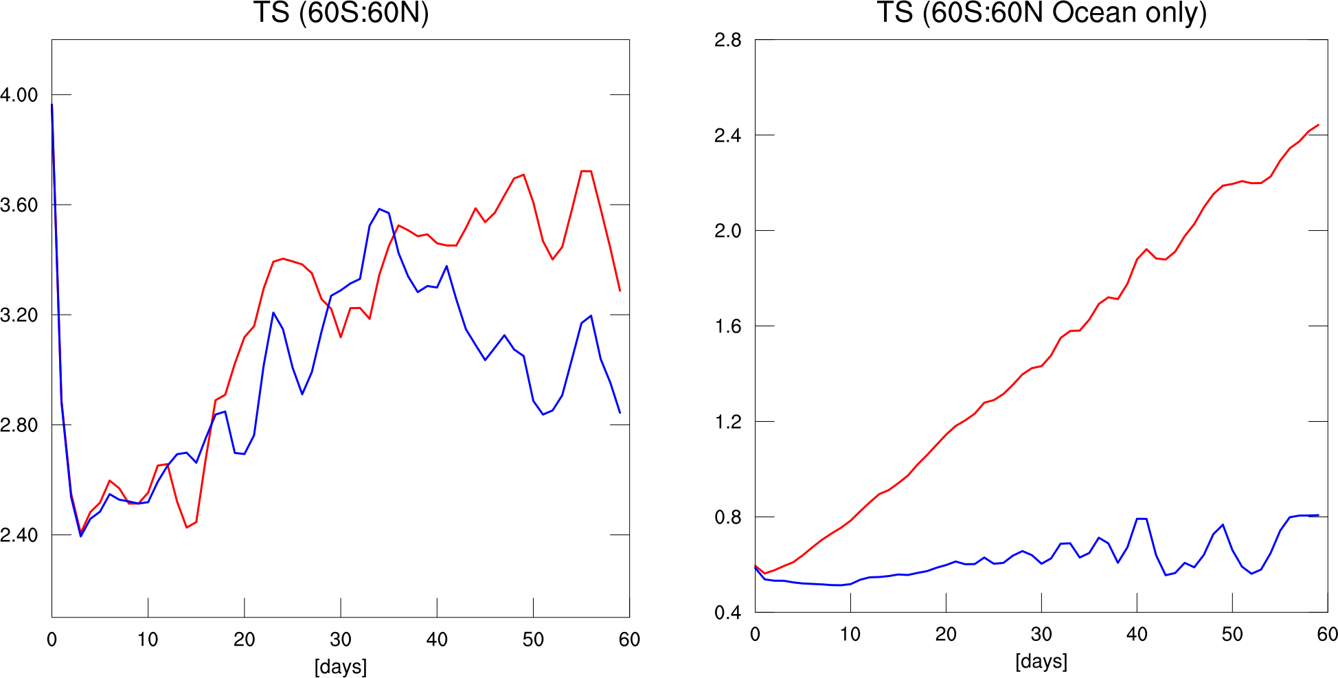
To illustrate the difference between the fixed and transient SST approaches I ran two 60-day simulations starting from the arbitrarily chosen date of 2005-06-01. The plot below shows the root mean squared error (RMSE) of near-surface temperature over 60S-60N relative to ERA5 data for all points (left panel) and ocean-only points (right panel). It should be clear from the right panel that the red curve represents the simulation where SST is fixed using the initial data on 2005-06-01. It's unclear how to attribute the "error" exhibited by the ocean only points in the case shown with the the blue line, but I suspect it is a combination of disagreement between NOAA/ERA5 data and remapping errors. Nevertheless, this analysis demonstrates that the expected error growth over ocean regions does not equate to a large difference in error when land points are included.
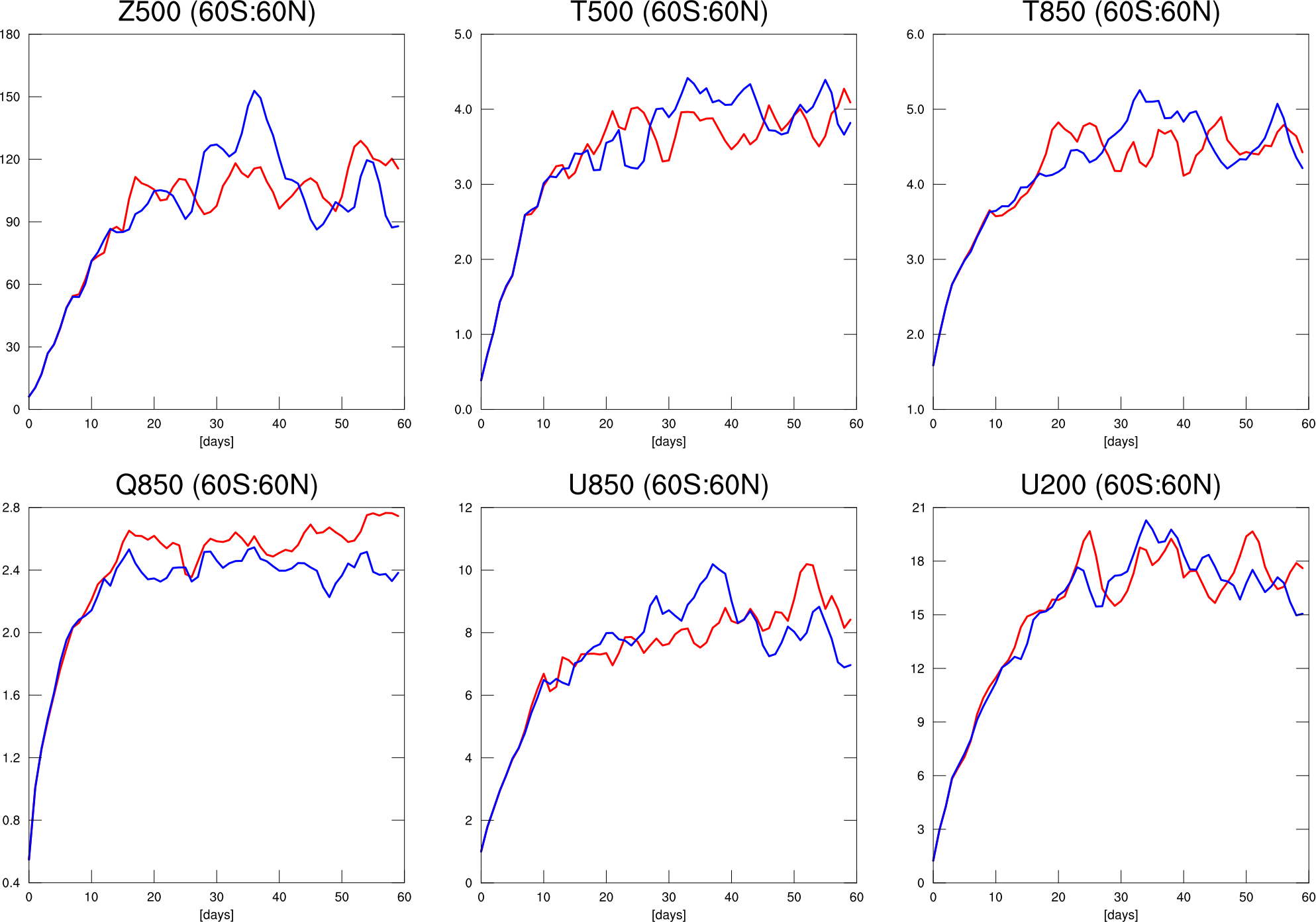
We can come to a similar conclusion by looking at the RMSE of several typical fields used to assess model skill, as shown in the plot below. The case with transient SST does seem to be more accurate, but the in the early period there is very little difference in the error growth and the error appears to saturate at a similar time in both cases. Thus, while transient SSTs are likely preferred in many cases, it may not be worth worrying about in many other situations
Another thing to consider is the size of the data. For a typical ne30pg2 experiment the size of one year of SST and sea ice data is comparable to the size of the atmospheric initial condition file. I've copied some file sizes from example files produced by HICCUP below to illustrate this:
528 KB - 1-day of regridded NOAA SST/ice data file
181 MB - 1-year of regridded NOAA SST/ice data file
193 MB - A single atmosphere initial condition file
We plan to implement other methods in the future for handling the time of SST data to be more flexible for hig-res runs, such as specifying a specific window of SST/ice data to remap and include in the file output file.