Using google earth engine, model builder, ArcGIS, Fuzzy AHP
Title: HABITAT SUITABILITY MAPPING OF PYGMY BLUE WHALE (B. m. indica) IN SRI LANKA USING A GIS-BASED FUZZY AHP ANALYSIS
ABSTRACT:
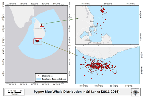
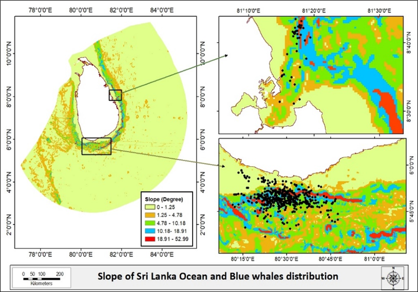
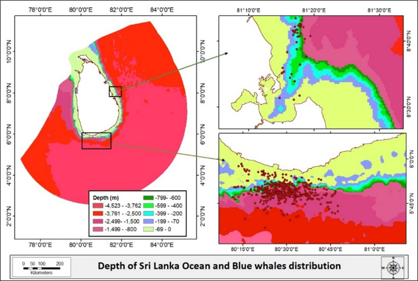
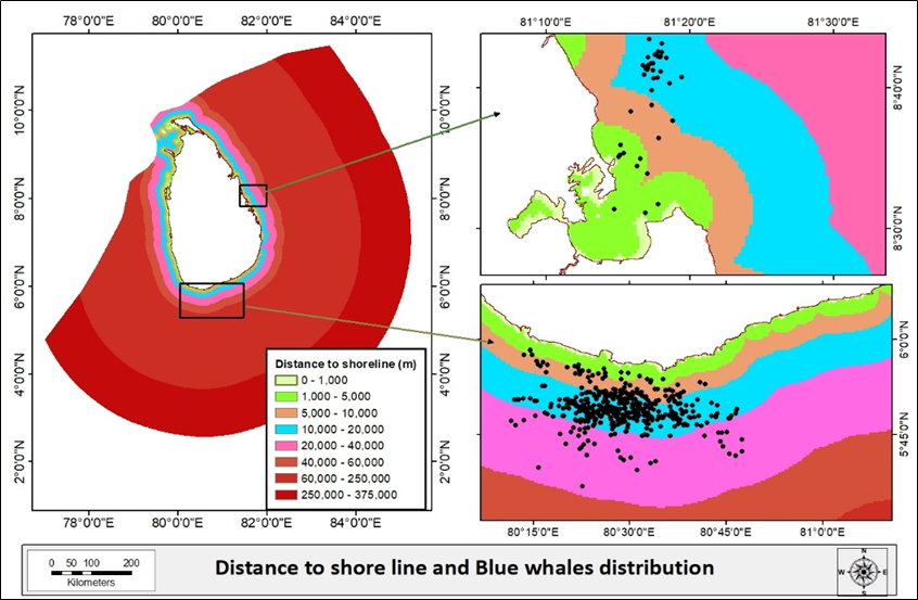
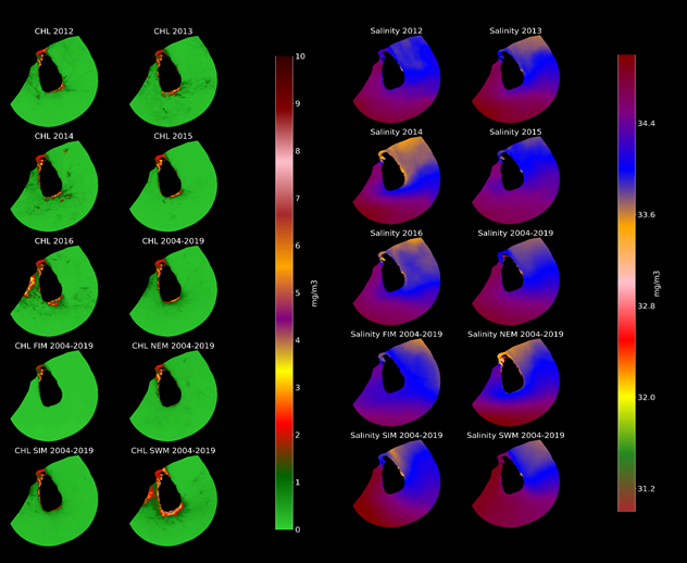
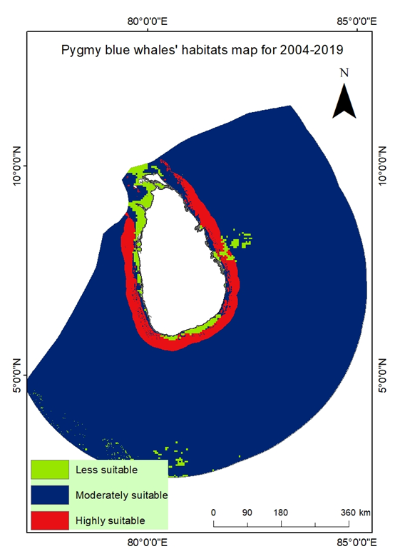
Sri Lanka is a hotspot for pygmy blue whales. The current blue whales’ studies in Sri Lanka depend on boat surveys, which operate seasonally and in only two locations. Therefore, it is essential to model their habitat suitability in the Sri Lankan Ocean using limited survey data and habitat modeling techniques. The study aims to model pygmy blue whales’ habitats distribution around Sri Lanka by Fuzzy AHP technique-based GIS. The study area was the ocean around Sri Lanka territory. The study used the data from the years from 2004 to 2019. Bathymetry criteria: slope, distance to shoreline, water depth, and ocean environmental criteria: chlorophyll a (CHL), Sea Surface Temperature (SST), and Sea Surface Salinity (SSS) was used. Six criteria maps were created based on optimum living conditions of pygmy blue whales. The questionnaire data were analyzed using FAHP pair-wise matrix and resulted in normalized fuzzy weights for every six criteria. A spatial model runs in ArcGIS 10.7 to model blue whale habitats’ suitability areas. Validation was done by calculation of the ROC curve and the AUC values. The blue whales’ habitat map of Sri Lanka (2004-2019) identified the most suitable areas around Sri Lanka, except the Northern part of Sri Lanka, with high accuracy. Highly suitable areas consist of near-to-shoreline regions and along the continental shelf area, displaying optimum productivity. Seasonal movements of pygmy blue whales around Sri Lanka can be visualized as highly suitable, moderately suitable, and less suitable. During the northeast season, whales are highly gathered around the west and south coast; during the First inter monsoon, whales are highly gathered around Sri Lanka and are known as peak season. During Southwest, monsoon whales are highly gathered around the west and northeast coast, and finally, during the Second inter monsoon, whales are highly gathered around Sri Lanka except in northern areas. Therefore, pygmy blue whales’ habitats map, based on fuzzy AHP, are accurate and can provide direction for future prospecting.
Keywords: pygmy blue whales, habitat modeling, Google Earth Engine, fuzzy AHP
Research questions of the study are,
- How to map highly suitable, moderately suitable, and less suitable areas of blue whales distribution in a poorly understood marine ecosystem with less number survey data using GIS?
- How pygmy blue whales’ habitats are changing in different monsoon seasons?
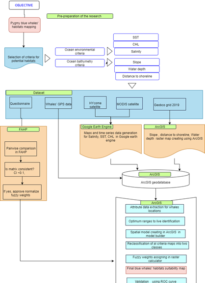 The conceptual framework of the study
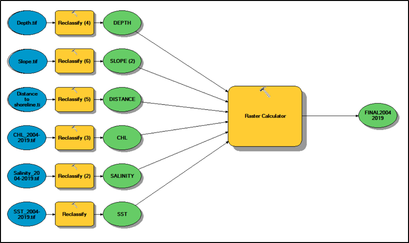
Six maps for criteria map generation
Sptial model for habitat mapping (in Raster caculator, weightage of each critera were added. )
Final suitbaility habitat mapp- blue whlae distribution in Sri Lanka
Validation was done using ROC curve analysis in ArcGIS.